
|
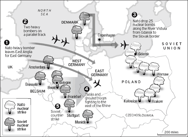
The map below outlines the nightmare of nuclear war in Europe. The newly elected government of Poland released this document as part of releasing its secret Warsaw Pact military archives. This is a 1979 map revealing the Soviet bloc's vision of a seven-day atomic holocaust between NATO and Warsaw Pact forces. The defense minister, Radek Sikorsky, showed off the map at an emotional press conference. He described it as a "personally shattering experience", pointing to a long line of nuclear mushroom clouds neatly stamped along the Vistula, where Soviet bloc commanders assumed that NATO tactical nuclear weapons would rain down to block reinforcements arriving from Russia. About two million Polish civilians would die in such a war, and the country would be all but wiped off the face of the Earth, he said. On the map, western Europe lay beneath a chilling overlay of large red mushroom clouds: Warsaw Pact nuclear strikes, using giant warheads to compensate for their relative lack of precision. Soviet bombs rain down on cities from northern Denmark down to Brussels, the political headquarters of NATO. Large red clouds blot out cities such as Hamburg, Frankfurt, Stuttgart, Munich and Baden Baden, Haarlem, Antwerp and Charleroi, above the Franco-Belgian border. Also on the map, smaller blue mushroom clouds showed expected NATO targets - most of them relatively precise attacks - including strikes on Warsaw and Prague. Perhaps because the map shows a limited war game exercise, entitled Seven Days to the River Rhine, rather than full invasion plans, troops stop at the Rhine, and there are no attacks or bomb strikes on Britain, or on France. Large blue NATO nuclear bombers are shown flying out of bases in East Anglia, and squadrons of NATO fighters are shown scrambling from Danish bases into combat over the Baltic. |
|
The above information comes from a story by David Rennie, titled "World War Three Seen Through Soviet Eyes." |
![]()
< War Studies > < Website Directory >